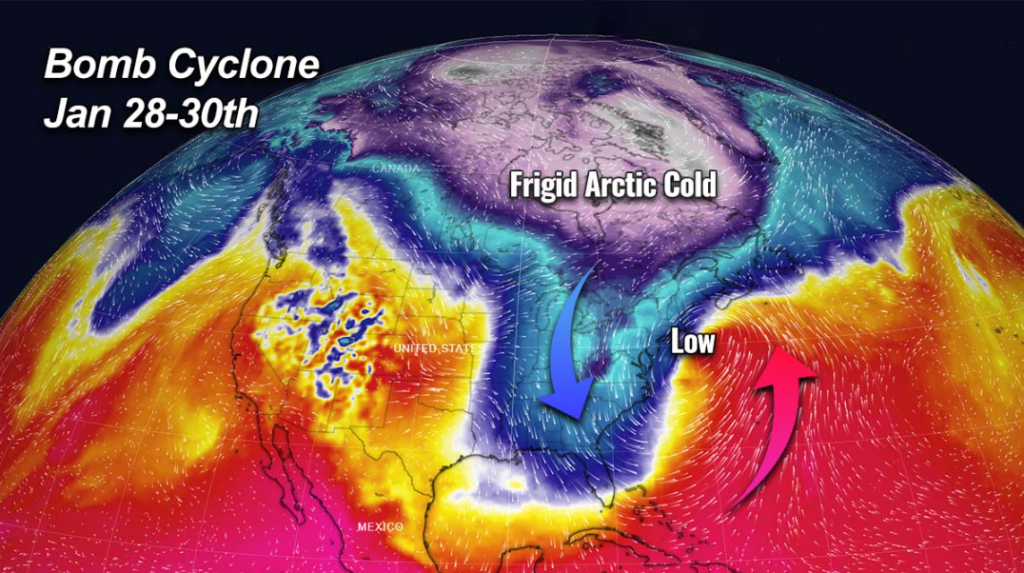
After a month-long absence, a “dangerous” arctic air mass will return to the United States this weekend. Temperatures in the central United States are anticipated to fall considerably below normal, and the balmy start to 2023 will come to an end as winter makes a roaring comeback throughout the Northern Plains and Upper Midwest. Because this arctic air mass is predicted to bring frigid temperatures and potentially dangerous situations, residents in impacted areas should exercise care.
“Dangerous low temperatures and wind chills are expected in the Northern Plains and Upper Midwest until early next week,” according to the Climate Prediction Center. “For the weekend and into early next week, expect substantially below-normal temperatures throughout the central/northern Plains to interior areas of the Pacific Northwest.”
Across much of the northern tier of the United States, high temperatures will be in the single digits or perhaps sub-zero, ranging from 25 to 40 degrees below average. Wind chill advisories have been issued for parts of Minnesota, North Dakota, Colorado, Nebraska, Kansas, and Montana due to extremely cold overnight lows.
“This would be the coldest weather for this region since Christmas, with highs from eastern Montana to northern Minnesota likely lingering below zero for Saturday through Monday, and maybe into Tuesday,” the forecast centre stated.
Many people may be surprised by these temperatures, given how mild January has been. Both Chicago and Kansas City are more than 9 degrees above usual for the month, and Minneapolis and Oklahoma City are at least 6 degrees above normal.

The abrupt change from moderate to extremely cold weather may take individuals off guard. For example, Bozeman, Montana, will swing from a high of 33 degrees on Friday to a high of -3 on Sunday, with more than 40 consecutive hours below zero. A high of 33 degrees in Minneapolis on Friday will drop to 3 degrees on Monday. Saturday’s high temperature in St. Louis will be 56 degrees. However, the peak temperature will drop to 36 degrees on Sunday before dropping to 16 degrees Monday night.
Western cities will likewise see precipitous declines. Denver’s maximum temperature will drop from 30 degrees on Saturday to 7 degrees on Monday. Add some wind, snow, and ice to the mix.
This weekend, air temperatures aren’t the only thing to be concerned about. Winds may gust to 20 to 30 mph throughout most of the High Plains and Midwest. While it may not seem like a lot, frostbite may begin relatively quickly when the air temperature is already so low.
“Wind chills in some places might approach 40 degrees below zero at times. “Highs in the 0 to 10 degree range are possible as far south as northeast Colorado and northern Kansas,” according to the forecast centre.
At such temperature, exposed skin can become frostbitten in 10 to 15 minute. Another worry about the wind is how it may affect snowstorms. Travel will be challenging due to blowing snow and poor visibility.
“This weekend, the upper level wave train has another snow maker for us,” said the National Weather Service office in Milwaukee, Wisconsin. “From midday Saturday through Saturday evening, much of southern Wisconsin may get light to moderate snow.”
On Friday, winter weather began to impact travel in portions of the Midwest. According to the Wisconsin State Patrol, a part of Interstate 39/90 between the communities of Beloit and Janesville in Wisconsin was closed Friday afternoon due to an 85-car pileup. According to authorities, at least 21 individuals were brought to surrounding hospitals with non-life threatening injuries.
Snow is anticipated to fall from the Cascades to the Rockies and into the Great Lakes area on Saturday and Sunday. Over 18 million people are under winter weather advisories or winter storm warnings.
Throughout general, 2 to 4 inches of snow will fall in southern Wisconsin, northern Illinois, and much of Iowa, however these fast but heavy snow burst episodes make it impossible to predict who will receive the most snow.
“An additional narrow band of 4-6″ of snow is anticipated from northern Iowa to Lower Michigan by early Sunday,” the forecast centre warned.
While snow is expected to be more prevalent further south, at the Iowa/Missouri border, the National Weather Service office in Des Moines warns of “a brief period of freezing rain and very light glazing of ice Saturday afternoon.”
Snow will also fall in the Intermountain West this weekend. Through Monday, much of Wyoming, Montana, Idaho, Colorado, and northern Utah may receive light to moderate snow. The biggest precipitation, however, will fall at higher elevations in Wyoming and Colorado, where several feet of snow is conceivable.
